CHECKWIND
This is a fully integrated wind load calculation tool that automates the calculation of site-specific wind load parameters.
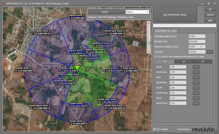
CHECKWIND requires you to simply select or double-click on the site address from an online map and then wait for a few seconds while it determines the site topography and detects the dimensions of all shielding structures that are within the shielding area of influence. It then calculates and returns the design wind speeds together with the terrain, topographic, direction and shielding multipliers for the eight key wind directions.
It is currently available to use with the following standards and calculates the parameters as below:
AS/NZS 1170.2: 2021
Vr, Region, Md, TC, Mz,cat, Ms, Mt, Mc
AS/NZS 1170.2: 2011
Vr, Region, Md, TC, Mz,cat, Ms, Mt
IS 875 (Part 3): 2015
Vb, TC, k2, k3
You should refer to the relevant wind code for details of the various parameters that can be generated by CHECKWIND as well as the inputs required for each wind load tool. It is available for use in SPACE GASS within the following tools:
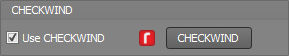
You can access the tool by ticking the "Use CHECKWIND" option in the relevant input screen. If CHECKWIND results already exist from a previous session and you want to re-acquire the results, possibly for a different site or for other changes you have made to the model, the "Use CHECKWIND" option will already be ticked and you should click the "CHECKWIND" button.
CHECKWIND Input
Once the CHECKWIND tool opens it displays a map that you can use to select the site location. If the CHECKWIND map won't open then check that your internet connection is allowing sufficient access as documented below.
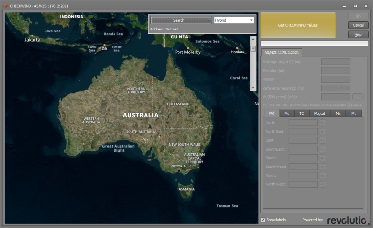
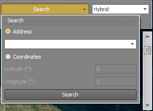
To enter the proposed site location, click the search button and enter the details by typing an address, entering coordinates or by double-clicking on the map. By default, the country shown will be the same as the selected wind code or the SPACE GASS country code.
Once the location has been set, you can activate the CHECKWIND calculations by selecting the “Get CHECKWIND Values” button. A loading bar will display as the data is obtained and calculations are made for the site.

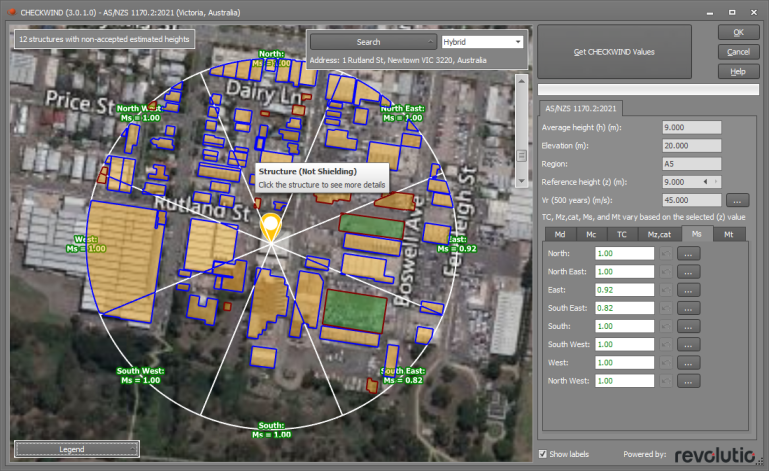
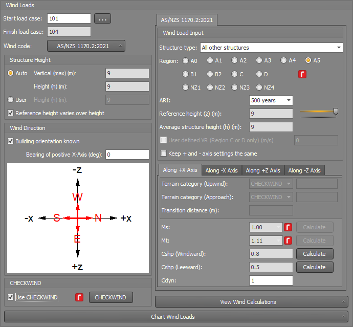
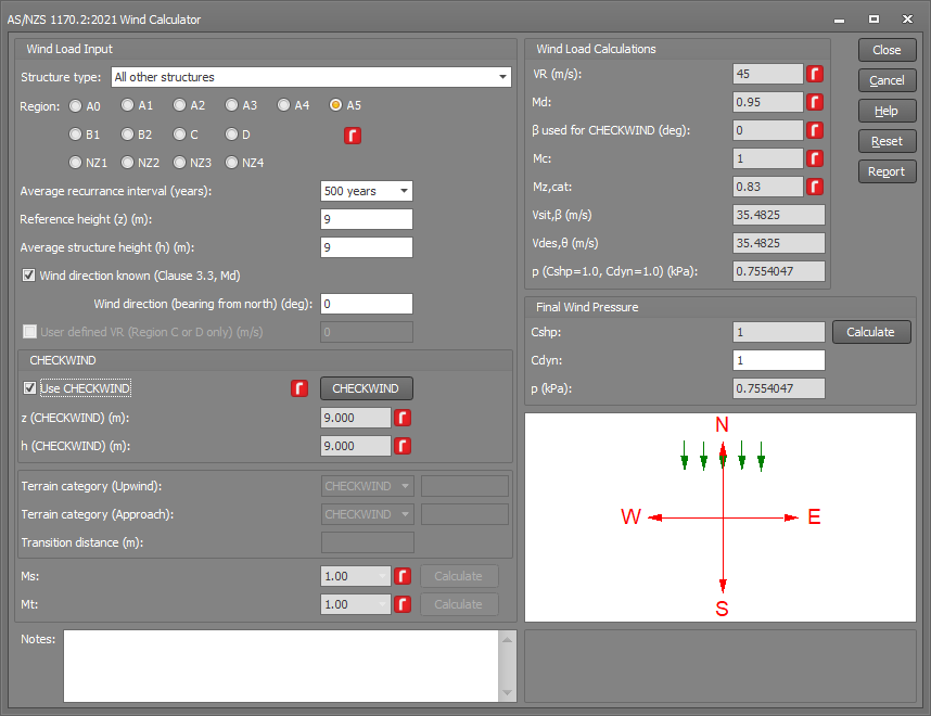
CHECKWIND Results (AS/NZS 1170.2:2021 and AS/NZS 1170.2:2011)
Once the data has been obtained, it will be displayed in the form on the right-hand side as shown below.
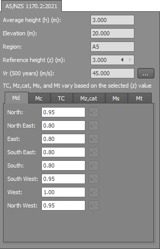
Average height (h)
This is the structure height set in the form that CHECKWIND was selected from.
Elevation
The elevation at the site location.
Region
The wind region (for AS/NZS 1170.2).
Reference height (z)
CHECKWIND will calculate 12 z values between 0 and h. Values of TC, Mz,cat, Ms, Mt are based on this z value. You can cycle between the z values via the arrows.
Vr
Shows the windspeed based on the recurrence interval (ARI) selected in the input dialog. The tabbed section then outputs the calculated design parameters based on the code selected and cardinal sectors.
Md
This is a calculated value that you can edit. CHECKWIND calculates the Md values based on a generic structure type and then updates the calculated values in the Md table if you have selected a specific structure type (eg. Md=1.0 for chimneys, tanks and poles as per AS/NZS 1170.2:2021 clause 3.3). If a calculated Md has been updated then you can see its calculated and updated values in a tooltip if you hover over it in the Md table.
Mc
This is a calculated value that you can edit.
Terrain Category, TC
The terrain category is calculated and shown for each wind direction. The overlay map shows how each sector is calculated. If the reference height (z) is adjusted, the values will update automatically. Clicking the TC chart button will display a graph of TC vs Z for the relevant direction.

Mz, Cat
This is calculated based on the TC results with the same overlay shown. The result is also adjusted based on the reference height and a graph can be displayed by clicking the same chart button.
You can edit these results and they will then be shown as a user generated entry. A user defined value can be reset back to the calculated value by clicking the reset button.
Ms
CHECKWIND calculates values for Ms in each direction and displays a map of the structures used to determine the shielding value. The result is adjusted based on the reference height and a graph can be displayed by clicking the chart button.
Note that if the above segmented circle overlaid on the map is not smooth or if it wobbles while being displayed then changing to a different render type could fix this. If you have this problem then you should go to the SPACE GASS Settings menu => "General Preferences" and try changing the "CHECKWIND map render type". The best setting depends on your graphics card and so it is usually a matter of trial and error to determine which render type works best for you.
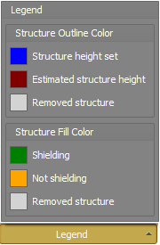
The overlay map and legend show which structures are providing shielding and if their height is known, estimated or removed.
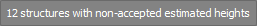
Depending on the location, it is possible that a regular shape such as a carpark may sometimes be mistaken for a shielding structure and so please verify each highlighted structure carefully, especially the ones that have an estimated structure height as shown by the note "x structures with non-accepted estimated heights" in the top-left corner of the map .
For each structure, you can click on it and then adjust its height and accept or remove it from the calculations via the “Accept Estimated Height” or “Remove Structure” buttons.
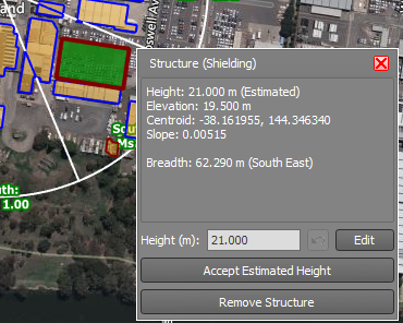
Where structures have been removed or changed, the calculated Ms value for that direction will indicate the user change and will include a warning symbol  if the calculated Ms value is different to the original CHECKWIND value. If you click the Reset button then any changes you have made to remove structures or change their heights will be undone, and the affected Ms values will revert back to their original CHECKWIND values.
Mt
Mt is calculated and shown for each direction based on the reference height. If the reference height (z) is adjusted the values will update automatically. Clicking the chart button will display a graph of Mt vs Z for the relevant direction. You may also adjust each value manually.
CHECKWIND Results (IS 875 (Part 3) : 2015)
Once the data has been obtained, it will be displayed in the form on the right-hand side.
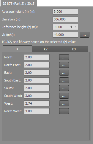
Average height (h)
This is the structure height set in the form that CHECKWIND was selected from.
Elevation
The elevation at the site location.
Region
The wind region (for AS/NZS 1170.2).
Reference height (z)
CHECKWIND will calculate 12 z values between 0 and h. Values of TC, k2 and k3 are based on this z value. You can cycle between the z values via the arrows.
Vb
The basic windspeed at the site location.
Terrain Category, TC
The terrain category is calculated and shown for each direction. The overlay map shows how each sector is calculated.
If the reference height (z) is adjusted the values will update automatically. Clicking the TC chart button will display a graph of TC vs Z for the relevant direction.
k2 & k3
These values are calculated and shown for each direction based on the reference height. If the reference height (z) is adjusted then the values will update automatically. You can also adjust each value manually. Clicking the chart button will display a graph of k2 vs Z or k3 vs Z for the relevant direction.
CHECKWIND Results
Values that CHECKWIND has calculated will be displayed in SPACE GASS with a CHECKWIND icon ![]() in the relevant input form.
in the relevant input form.
Wind Load Generator
Wind Calculator
Internet requirements
CHECKWIND requires internet access to the Revolutio API and various mapping data sources, and so your internet connection needs to allow the following:
-
TLS 1.2 enabled (Transport Layer Security) https://docs.microsoft.com/en-us/mem/configmgr/core/plan-design/security/enable-tls-1-2-client
-
Access to the Revolutio CHECKWIND.API will start with https://api.revolutio.com.au/v2/
-
Access to Google Geocode data for Address to Coordinates, or Coordinates to Address will start with https://maps.googleapis.com/maps/api/geocode/
-
Access to BING Map data for displaying maps in the form will start with https://dev.virtualearth.net/REST/v1/